Digital Systems
Image Gallery
Research
- Nav Station – …magnetic compasses (both fixed and hand-bearing); binoculars; sextant; clock; water depth indicator; speed indicator; distance-run indicator; and electronic devices including radio direction finder, Loran-C, Decca, Omega and satnav….realize that all navigational system are subject to troubles ranging from degradation to total failure….thus there are advantages in having redundant gear aboard to provide both a backup should one system fail and a warning of possible trouble should the two systems disagree. (Desirable and Undesirable Characteristics of Offshore Yachts, p. 208)
- Weather and Communications Instruments – this group includes the barometer, wind speed and direction indicators, temperature and humidity indicators, the weather facsimile machine, and various radios, including single-sideband, VHF-FM, the general-purpose communications receiver, and ham. In addition to these deices, the stored knowledge available in a modest shelf of well-chosen technical and instructional books, while hardly to be classified as an “instrument,” will sooner or later provide a lot of comfort at sea. In this library there should be at least an elementary text on meteorology. Read it in good weather rather in distress. It will help any sailor get the most out of available weather data and, in particular, help him or her to make local predictions based on weather forecasts for large areas. (Desirable and Undesirable Characteristics of Offshore Yachts, p. 216)
- Need: Depth sounder, Speed & Log, GPS….Want: Wind speed, Plotter….Like: Wind direction, RADARAIS RADAR, Fluxgate compass, Weatherfax (www.cruisersforum.com)
- The first rule about marine electronics is that electricity and salt water don’t mix. Once electrical wiring and appliances are wet, corrosion is swift and insidious. The only way to avoid the hassle and frustration of failed electronics is not to have them. Considering that for 99.9% of human history electrical power was unharnessed (yet sailiors voyaged round the world), it should be a worthwhile sacrifice for any of us to live at least a short while without it. Living simply better prepares one to cope with the exigencies of nature and the vagaries of the man-made equipment. As much of the boat’s gear as possible should be repairable by the crew. In many parts of the world, parts are simply unavailable….sailors who have such devices on board gradually develop unconscious dependencies on them, which reduces their ability or readiness to handle the problems without the aid of electronics…but one shouldn’t overlook the advantages of such equipment, such as SSB, which in the event of a medical emergency at sea may be your only means of communicating with a physician….Before going off cruising, one should plan carefully for the electronics he desires on board. If the list gets too lengthy, it could delay departure by several years. (Upgrading the Cruising Sailboat, p. 258)
- You’ll need to determine what your needs are now, and what they may be in the future….taking into account additional equipment that you may wish to add in the future, as well as considering both your current sailing / cruising locations and future plans…..(what works well in the Bahamas, may not be so nice in Greenland, etc…) Here’s just some of my uses:When sailing offshore, on long voyages, I have 2 separate GPS units running 24/7 (A Raymarine GPS 125 and a Garmin GPS 76, which has it own separate battery back-up)….this gives me constant lat/lon data, that I can plot on my paper charts (along with celestial and/or DR plots), and lat/lon data sent via NEMA to both VHF-DSC and SSB-DSC radios (Icom M602 and M802) and my Standalone AIS receiver, with its own low-power LCD display…..and this set-up also give me BTW, DTW, VMG, etc. to specific waypoints that I’ve entered…..Sometimes a waypoint can be just a arbitrary position I pick to change course at (10 miles or 1000 miles away), OR a waypoint can be a position I pick to sail to, to avoid weather or FIND some wind, LOL……or it could be a destination, etc…..I also have 2 additional handheld GPS units (all Garmin GPS 76) with a BIG supply of AA batteries and additional 12vdc power cords, AND a spare Raymarine GPS 125, as well as at least 5 accurate time pieces (3 of them, my own watches), and my Tamaya sextant, almanac, and reduction tables……This is all very low-power consumption and very reliable……and is all in excess of the Raymarine E 120 and E 80 chartplotters, which are used only when needed, for radar, when offshore…..and as back-up to other information/charting…. (http://www.cruisersforum.com/forums/f121/the-chart-table-32505-3.html)
- …the realities of economics dictate that I confine my electronics to bare essentials: Depthsounder, knotmeter, EPIRB, VHF radio, compass and RDF – that’s it. (Upgrading the Cruising Sailboat, p. 273)
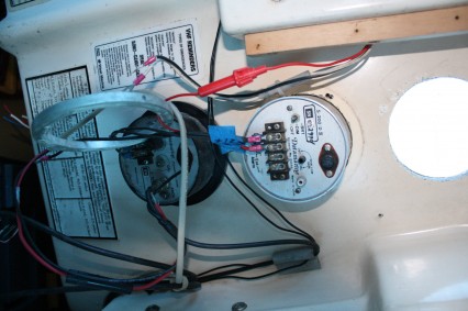
- four large (3.5″) holes required to mount the Raymarine ST-60 instrument suite–knotmeter, depthsounder, wind instruments, and autopilot. I had previously purchased a new carbide-tipped hole saw for this very task, and after carefully laying out the instruments using the supplied templates, I prepared to cut these holes. The task turned out to be far more challenging than I had anticipated, as the very new and very sharp hole saw tended to grab the relatively thin fiberglass of the cabin trunk bulkhead and stop, forcing the drill–and the operator’s wrists–to twist rather violently around. I soon traded my normal cordless drill for a large right-angle monster to provide me with a better grip, and took the remaining cutting very slowly, eventually working from both sides of the cabin trunk.The end result was damage-free and agreeable, but I was surprised at how long it took to actually get all of these large holes cut. Afterwards, I reamed the holes out slightly with a drum sander in my drill (the holes require a 90mm bit, which was not readily available; the 3.5″ bit I purchased was actually 89mm) and then installed the new instruments with the supplied hardware. These instruments represent a very nice little package that we will eventually interface (using the Raymarine SeaTalk protocol) with the other electronics being installed. Much more to come on this in the coming weeks. (http://www.lackeysailing.com/kaholee/september2007/91107.htm)
- Common displays – Radar, Depth/FF, Speed log, Wind, GPS/Plotter, AutoPilot.
- …devices that can help the crew evaluate and improve the boat’s speed and pointing ability…can be valuable when cruising….they are boat speed, distance run, and relative wind speed and direction devices that provide the raw data that are fed into more advanced devices that keep a dead-reckoning plot, calculate the true wind speed and direction, or analyze boat performance. In addition, a boat may carry a computer. (Desirable and Undesirable Characteristics of Offshore Yachts, p. 219)
- …performance instruments are not for everyone. Installations require considerable study and planning, and demand more than the average amount of maintenance and operator skill. Whenever you use any instrument of this sort, keep in mind that the output is most accurate and reliable when, and only when, the calibrations of the basic data-producing instruments – the relative boat speed and wind speed and direction – are as good as they can be made. (Desirable and Undesirable Characteristics of Offshore Yachts, p. 219)
Computer
- a small sized laptop on the hull side of the table in a pull out drawer/shelf This one will have my electronic charts loaded and be hooked up to a USB GPS antenna. The centerline side will have a full sized laptop on the same pull out device for other work. This will keep all of the wires and cables out of the way. (http://www.cruisersforum.com/forums/f121/the-chart-table-32505.html)
- Years ago I made a SS bracket for my laptop; it folded up on the bulkhead forward and when in use it folded down on the table top and then slid toward the bottom edge of the table to be used. It was pretty slick until the laptop needed replacing and of course the new one was bigger! I used those ball bearing drawer slides to make it slide down…. It should be easier now to make something, back then I had all those RS-232 bulky cables to deal with… (http://www.cruisersforum.com/forums/f121/the-chart-table-32505.html)
- Shuttle PC – a gamers PC it has all the power of a full sized PC in a tiny box. It has the advantage that it uses a standard hard drive so that makes upgrading or replacing that part easy. It also has built in graphics card that allows 2 monitors and s-video output. A built in high end sound card that i have connected to the stereo for tunes or watching movies on the TV. It has sound USB and fire wire ports on the front very handy. I have a NMEA combiner so i get GPS and wind speed and depth data on my monitor. Draw back is high power consumption but i find i only need the detail charts when i am inshore and likely have the engine running. I do plan to upgrade solar and wind generators so that should help too. This unit has a fluid cooled processor which helps in the enclosed installation. I also have a USB external hard drive for back up. I also use a old Panasonic tuff book as a backup. i bought both computers on EBay for about $150 each (http://www.cruisersforum.com/forums/f121/the-chart-table-32505.html)
- for PC’s on board i should check out those in car pc’s used by the car guys who are building their own PC systems in cars. (http://www.cruisersforum.com/forums/f121/the-chart-table-32505.html)
- I have been using standard PC’s you buy at discount in the mega stores or on the internet. You can get the latest and greatest for from $300 to $800 for the super fancy. …you want to find the make/model with the brightest LCD screen. Some units have dimmer screens which are cheaper to make but will not be viewable in the bright sunlight of the Tropics. You can also buy extension cables for your keyboard, mouse and monitor. Then leave the computer down below safely out of the elements and have the monitor and mouse/keyboard up in the cockpit. You can build a splash proof enclosure for the monitor or buy some 2 gallon zip-lock baggies and place it over the monitor like a hat. Wireless keyboard and mouse can eliminate the cables for them.- – You can buy on-line the Chinese “hockey-puck” 20 channel USB GPS units for under $25. They are designed for the automobile roadmap systems. The marine stores sell the same type GPS for $200+. The PC computer navigation applications make great primary or back up navigation if you have a chart plotter. The “hockey puck” GPS is powered by the computer so if the main ship’s power fails you have the battery inside the computer or power from a genset/inverter to keep your navigation system up and running. (http://www.cruisersforum.com/forums/f121/the-chart-table-32505.html)
- using a laptop with SeaClear 2w2 and NOOA charts for 2 or 3 years now and have been dogging buying the “inevitable” chartplotter. I say inevitable because MFDs are getting more common and I like the idea of a single display with everything on it. After starting to go through this thread, however, I hit on the idea of an on board “server” to handle everything navigation related. (http://www.cruisersforum.com/forums/f121/the-chart-table-32505.html)
- With a little Yankee ingenuity your don’t need to spend mega thousands on nav equipment. Discount, web, or mega-store equipment works fine and last several years so long as you keep water away from it. Locating the main computer below and using cables or wireless solves that problem. The monitor can easily be put into a D-I-Y box made from Star-board plastic and plexiglass or just use the large baggie. Every few year my eyes get less efficient or my arms are growing shorter – so I need to “upgrade” to a larger LCD screen. Using low cost (relatively speaking) LCD monitors make the “stepping up” reasonably easy on the wallet. I started 10 years ago with a 15″ monitor and now I am up to a 22″ LCD monitor. I like being able to split the screen and have my nav running on one half while I have movie or concert running on the other half. And when anchored we can watch full screen movies on the monitor while lounging in the cockpit. Its all up to your imagination how you want to arrange the stuff. (http://www.cruisersforum.com/forums/f121/the-chart-table-32505.html)
- Fairly common to include a … portable computer as part of the gear on racing yacht. These machines can be hooked up the other instruments and used to monitor, record, display and print out information on the performance of the boat, together with other data such as wind direction and current. In conjunction with polar curves, computers can help the navigator determine the best course to take when various combinations of wind and current are available. Some computers have been programmed to monitor wind, boat speed, and position data while the navigator is sleeping – and then to wake the navigator if the situation demands attention. (Desirable and Undesirable Characteristics of Offshore Yachts, p. 221)
Global Positioning System (GPS)
- The global positioning system (GPS) is a satellite-based navigation system consisting of a network of 24 orbiting satellites that are 11,000 nautical miles in space and in six different orbital paths. The satellites are constantly moving, making two complete orbits around the earth in just under 24 hours. (www.boatus.com/boattech/gps.htm)
- Key Upgrades – The key upgrades we list are differential built-in, upload/download capability, extra-large screen, color screen, built-in database of landmarks, tide chart capable, remote antenna included, accepts software cartridges or CD downloads. Differential Built-In:Is an excellent feature if you are concerned about improving your GPS accuracy over the error caused by Selective Availability. Upload/Download Capability:Good for those who like to plan routes at home on a personal computer and download them into the GPS. You can then make modifications on the information in the GPS, marking new fishing spots etc., and upload that back to your computer. Extra-Large Screen:Good for larger boats where viewing information across the cockpit is necessary. Also helpful if the GPS is interfaced with several other instruments, and all the information is detailed in smaller windows on one screen. Built-In Database of Landmarks:Helpful on land-based units by adding greater detail to the built-in basemap. Tide Chart Capable:Helpful when you need information on the tides quickly and at your fingertips. Remote Antenna Included:Important for improved accuracy and “viewing” of satellites. Accepts Cartridges/CD Downloads:Necessary for detailed chart information and planning and plotting routes. (www.boatus.com/boattech/gps.htm)
- Basic Handheld GPS – These units are small, lightweight, and portable, so you can take them virtually anywhere. They operate either on Alkaline or NiCad batteries with an average battery life of 12-24 hours of constant use. Most have 12-parallel channel receivers which lock onto satellites quickly and stay locked on in dense cover. Simple keystroke commands ease use and many are just as sophisticated as their fixed-mount counterparts. The built-in displays are usually LCD, for low power consumption, and can be either alphanumeric or graphical. Backlighting makes the displays easy to read both in bright- and low-light conditions. Some units accept an external antenna for better satellite reception. (www.boatus.com/boattech/gps.htm)
- Handheld GPS with Programmable Memory – In addition to the location and plotting function of the basic handheld GPS, many units are available on the market that can provide significantly more data for the user. Advanced units today use programmable internal memory that can accept information downloaded from your computer to a CD. In addition to detailed marine cartography, street level mapping, topographic maps, hot fishing spots, and general use points of interest information such as restaurants, addresses, phone numbers, etc. are available. The amount if information (the size of the chart area as an example) is dictated by the amount of memory storage capacity the unit contains. Not surprisingly, the more memory the unit has, the more the unit costs. Some handhelds on the drawing board will be designed to use external memory chips that can be programmed by the factory with information or the end user can purchase the equipment required to program these memory chips using their computer. This option is currently available for many of the fixed-mount chartplotters on the market. (www.boatus.com/boattech/gps.htm)
- Fixed-Mount GPS – These bring the convenience of the handheld to a unit that you can permanently mount anywhere on your boat. The fixed-mount units generally offer larger, more visible screens, more options, and better position fixing than the handheld units. Most units are water-resistant and can withstand a certain amount of water sprayed on them without damage. Some offer internal antennas for easier mounting options and others offer external antennas for clearer antenna line of sight to the satellites. (www.boatus.com/boattech/gps.htm)
Inclinometer
- The heel angle is another type of raw data used in these calculations. It is measured by an inclinometer that yields an electrical readout, which helps calculate leeway and improves the accuracy of the boat and wind speed devices by correcting for heel. (Desirable and Undesirable Characteristics of Offshore Yachts, p. 219)
Layout
- …instruments need to be clearly visible from the watchkeeping station, which needs a clear line-of-sight forward. Remember that on a cruising boat, the watchkeeping station is rarely at the…tiller because the boat is almost always being steered by an autopilot or wind vane. For this reason, it is better to mount the sailing instrument above the companionway hatch (the best place for all-around visibility) or on the cabin bulkhead (as long as they are not obscured by halyards and reefing line changing off the aft end of the cabintop) rather than on the pedestal. (Cruising Handbook, p. 78)
- you should also have any electronic displays (e..g, GPS and radar) readily visible and radios (VHF and SSB) nearby. (Cruising Handbook, p. 130)
- A 36” or larger chart table results in plenty of fascia space behind it in which to mount electronic equipment and electrical distribution panels. Given the rate at which electronic equipment changes…this panel should be designed for easy removal and replacement….In addition, the section of the fascia panel that is devoted to the distribution panels should hinge open such that full access is provided to all the wiring, which facilitates troubleshooting and upgrades. (Cruising Handbook, p. 133)
- Careful thought must be given to the placement of gear in the navigation stations, particularly radios (which contain magnets) and compasses (which don’t like magnets). (Cruising Handbook, p. 133)
- Radios can be located behind or to one side of the seated navigator, who should be able to wear the earphones while working at the table. (Desirable and Undesirable Characteristics of Offshore Yachts, p. 224)
- Regardless of manufacturer’s claims about how waterproof or weatherproof a particular unit is, mount it as though a single drop of water could ruin it – because it can. High and dry is the order of the day. Radios should be mounted up against the headliner or under the side deck….When you get a little water below and onto the wrong tack, it will immediately become obvious why low mounting is never a good idea. Do not mount electronics under the companionway or below an opening port, and make every effort to find a mount location that also keeps the unit out of direct sunlight and far from the engine heat and vibration. (This Old Boat, p. 300)
- On a minimally instrumented boat, all the navigator needs are a flat surface on which to lay out the charts and a place to stow them. The main cabin table and a bunk under the mattress will do fine. However, a regular navigation station is needed on boats with several instruments so that the indicators are clustered in a location where they can be seen by the navigator while he or she is seated at the table or standing by. (Desirable and Undesirable Characteristics of Offshore Yachts, p. 224)
Loran C (No Longer In Service)
- An extremely accurate system for fixing position that operates by receiving signals from several widely spaced transmitters on land and very precisely comparing the difference in arrival time of the signals. It is an outgrowth of old Loran-A…more accurate, automated, and computerized (there is a continuous automatic fix) and has a lower operating frequency.gives wider coverage and range and less trouble with sky waves…ability to calculate speed and course over bottom; by comparing these data with the compass and course and distance to a turning point or destination. If this information id displayed on a repeater in the cockpit, the helmsman can steer the exact course without the navigators having to give directions from the cabin. (Desirable and Undesirable Characteristics of Offshore Yachts, p. 214)
- Drawbacks – 1) not a worldwide system (Decca is used in Europe) Loran’s accuracy quickly degenerates near the limits of it’s coverage 2) being a complex computerized electrical system, Loran-C is subject to failure in many ways. 3) various kinds of electronic “noises” will interfere with loran signals, which are relatively weak as received…noise can be generated in the boat itself (e.g., flourescent lights) (Desirable and Undesirable Characteristics of Offshore Yachts, p. 214)
- …most simple ones are competitive RDFs. Since it is quite inexpensive for its navigational value, many boats carry a second as a backup. (Desirable and Undesirable Characteristics of Offshore Yachts, p. 214)
- Loran is an extremely accurate means of navigation that utilizes pairs of pulsed radio signals from land-based transmitters to give the yacht’s receiver a position fix. Accuracy is generally within an eight of a mile, which makes it extremely useful for coastwise navigation. Range is up to 700 miles from transmitting stations during daytime, and about 1,400 miles at night. (Upgrading the Cruising Sailboat, p. 264)
- Loran C often is more accurate than satellite navigation and unlike SatNav, provides continuous readouts. For the coastal sailor, Loran C is the thing to have, for the blue-water passagemaker, it’s SatNav. (Upgrading the Cruising Sailboat, p. 264)
- …[installation] generally include[s] the control unit, alternator capacitors to eliminate interference, the antenna and a ground wire. Loran is often wired directly to the battery for maimum powr and minimum interference. Typical full operating load is several amps. (Upgrading the Cruising Sailboat, p. 265)
- Current Loran Status – The federally operated Loran navigation system has been saved from a premature shutdown and may be operated by the federal government until 2008. The decision follows a high level meeting of the Department of Transportation, the Federal Aviation Administration, and U.S. Coast Guard officials.Operated by the USCG since the 1970s, Loran was targeted in 1994 for a shutdown as early as 2007 due to budget concerns, rather than remain operational until 2015 as planned. With over a million civilian users, most of them mariners, the prospect of Loran’s early demise created a furor among navigators who had hundreds of million of dollars of Loran equipment invested in their boats. BoatU.S. immediately launched a grassroots campaign to save Loran and has worked with members of Congress to secure funding for Loran.Loran and GPS are not competitors, but are systems with different strengths and weaknesses, as well as different failure modes, so that they complement each other well. The deliberate signal degradation through Selective Availability (slated to be eliminated by 2006 or earlier) is a pitfall of GPS receivers. Selective Availability does not affect Loran. Loran coverage by U.S. ground stations extends from Russia to the Caribbean and includes much of Canada. The system is worth keeping as a complement and back-up to GPS receivers. (www.boatus.com/boattech/gps.htm)
- Some performance instruments are able to determine local current set and drift by comparing the dead-reckoning fix (the position relative to the water) with the Loran fix ( the position relative to the bottom)…can be very valuable for safe passages in constricted, tide-swept waters in poor visibility. (Desirable and Undesirable Characteristics of Offshore Yachts, p. 220)
Radar
- A closed dome, 2 foot diameter antenna will give adequate range for sailboat use, and can be mounted on a mast or, failing that, on a post standing up from the deck….radar can be used anywhere in the world. (Desirable and Undesirable Characteristics of Offshore Yachts, p. 211)
- Radar works by emitting radio pulses at ultra-high frequencies, sweeping the horizon with its beam and showing on a screen the echoes that come back. A properly functioning radar instrument will mark the exact distance and bearing to any reflecting object in the line of sight of it’s antenna. In effect, radar provides a pair of eyes that see for miles around the boat in all types of visibility. If the readout screen can be located where the helmsman can see it from the wheel or tiller, the system provides instant short-range pilotage and collision avoidance capability for shorthanded crews. (Desirable and Undesirable Characteristics of Offshore Yachts, p. 211)
- Radar does have some limitations. while darkness and fog pose no problem, heavy rain and breaking waves (“sea clutter”) significantly degrade returns and target identification. And it is not effective when the boat is heaeling more than about 2 degrees, unless the antenna is installed on a self-leveling mount. (Desirable and Undesirable Characteristics of Offshore Yachts, p. 211)
- Hand-held sets…are available for skipper who do not wish to carry a full radar instrument. There is no screen with this device; echoes are indicated by audible tones in earphones, with the pitch varying with the proximity of the reflecting object. (Desirable and Undesirable Characteristics of Offshore Yachts, p. 211)
- See Desirable and Undesirable Characteristics of Offshore Yachts, p. 211, Fig. 14-2
Radio Direction Finder (RDF)
- The radio direction finder (RDF) has probably been more used by more years, by more mariners than any other modern electronic navigation system. While it is not as accurate as other devices, it is a useful and relatively inexpensive instrument that is most helpful in areas where visibility is often bad (Desirable and Undesirable Characteristics of Offshore Yachts, p. 211)
- The RDF operates by sensing the bearing toward a radio transmitter, which works on a frequency below the broadcast band and, typically, is installed as an adjunct to a lighthouse. While the RDF can be used to determine a line of position (LOP) and, using two or more LOP’s, to fix to an approximate position, it is often most effective for homing in on a destination near a transmitter. The effect range of some transmitters may be as large as 200 miles. (Desirable and Undesirable Characteristics of Offshore Yachts, p. 211)
- The type of RDF that is easiest to use…an antenna and a small magnetic compass in a hand-held package. This unit may contain its own radio receiver or be connected to a fixed radio below. Using this system, the navigator stands on deck or in the companionway, aims the antenna, listens for the transmitter’s Morse code signal through earphones, and, when the signal is inaudible (null), read the bearing off the compass. With this system, there is no need to take into account the boat’s precise heading, which is necessary when the RDF is fixed below the cabin…affected by many factors that change over time…rigging, lifelines, sails (if they are wet), and angle of heel. The loop of wire lifelines should be broken by using a rope lashing to attach them to one of the pulpits. (Desirable and Undesirable Characteristics of Offshore Yachts, p. 211)
- See information on how to create a deviation table from Desirable and Undesirable Characteristics of Offshore Yachts, p. 212
- …like many others, use[s] its own “D” size batteries and therefore [is] not dependent on the ship’s batteries….The more expensive models prevent 180 degree bearing error and automatically rotate to pick up the desired radio signal or beacon. The less expensive models are tuned manually….[mount] the instrument high on a shelf. Further, it should be well secured so it won’t be damaged by sliding around. By the same token, it should be easily moved for use on the chart table or wherever is most convenient, assuming it cannot be read or tuned on its shelf. Because it has its own power supply, no other installation is necessary. (Upgrading the Cruising Sailboat, p. 263 – 4)
Speedometer
- The backbone of dead reckoning – the basic skill of all passage-making – knowledge of the boat’s speed and distance covered over a known course. The compass gives the course, and a speedometer and log give the distance. The electronic speedometer and log are very useful instruments for pilotage and navigation, replacing the traditional taffrail log, which can be carried as a backup on a long voyage. Therefore, the speedometer ought to be one of the first instruments chosen. (Desirable and Undesirable Characteristics of Offshore Yachts, p. 210)
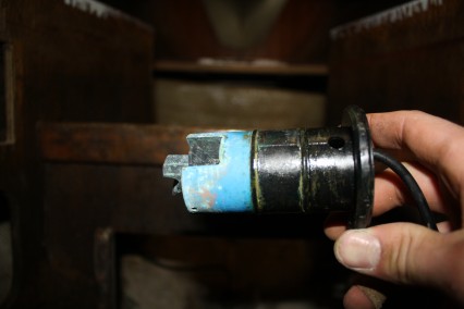
- There are speedometers whose readings can be expanded to detect and display minute changes in speed – a great help while trimming sails – and which can be tired into computers to indicate performance for given conditions. The transducers for these types of instruments are generally small paddlewheels or propellers. Of the two types, the propeller is preferred as is less likely to pick up weeds. Both types may be difficult to calibrate and must be pulled out and cleaned frequently. (Desirable and Undesirable Characteristics of Offshore Yachts, p. 211)
- These problems do not exist with a new type of transducer that measures the boat’s speed by sending sound waves through the water. The transducer should be located on the centerline about one-third of the way down from the keel to the forward end of the waterline. Time spent calibrating the speedometer will pay off handsomely in accurate dead reckoning as well as reliable measurement of boat performance. (Desirable and Undesirable Characteristics of Offshore Yachts, p. 211)
- A basic aid to dead reckoning (DR) is knowing how fast the boat is moving. The equation, speed x time elapsed = distance traveled, is fundamental. After you’ve sailed your boat awhile, you learn to estimate the speed of the boat fairly accurately even without a knotmeter. But to learn, you need some help, and a knotmeter is the instrument to use. (Upgrading the Cruising Sailboat, p. 260)
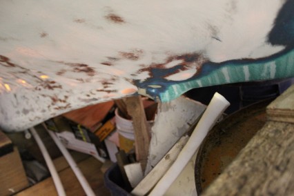
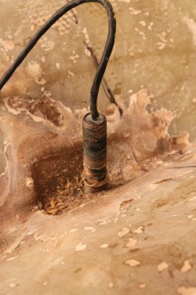
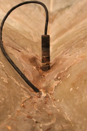
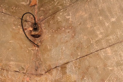
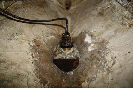
- Installing – If you select the thru-hull type, begin by carefully studying your hull for a suitable location…somewhere near the middle of the boat. The safest position from grounding damage is in the concave garboard curve. Use a hole saw for this purpose. Drilling from inside usually chips the gel coat on the outside, but not so much that it won’t be covered by the flange of the sending unit. if concerned about this, drill only until the pilot bit goes through the hull, then go outside and complete the hole. When installing something through the hull, especially below the waterline, the hole must be cut to exact specifications to ensure a tight fit….Use generous amounts of bedding compound such as polysulfide, enough so that when you tighten down the backing plate, compound oozes out both inside and outside the hull. It can be cut away after it dries…Avoid pulling the wire tight because it could chafe on sharp edges. If there is any doubt about this, wrap tape around the wire where it might chafe, or better yet, slip plastic tubing over the wire. The ultimate protection is to run the entire wire through PVC tubing, but generally the wires for knotmeters are well insulated and tough. (Upgrading the Cruising Sailboat, p. 261 -2)
- Knotmeters need calibrating (be suspicious of a unit that has no adjustment knob). This is best done by running the boat over a measured course free of wind and current Any known distance between two buoys or other land or sea marks is suitable. For example, if the distance between two buoys is 1.2 miles, and the time elapsed during the run (with steady throttle) is 18 minutes (0.3 hour), the knotmeter should read 4 knots (1.2n.m / 0.3h. = 4.0kn.0. Keep running the boat at the same throttle while you figure the equation, so you can adjust the knotmeter while running at the speed used during the test. (Upgrading the Cruising Sailboat, p. 262)
- Speed log impellers need to be mounted clear of interference, so do not install these components in the flow shadow of some other through-hull fitting or another hull feature that might create a disturbance. (This Old Boat, p. 300)
Time Keeping
- A crystal digital watch, cheap but highly accurate, is another blessing of modern technology. Each boat should carry at least digital timepieces for backup. An accuracy doesn’t seem to be a function of price to any important degree. Another kid of watch worth having aboard is a stopwatch, which many navigators prefer to use when taking the time during sightings and which can be very useful when “running your time” in poor visibility. (Desirable and Undesirable Characteristics of Offshore Yachts, p. 210)
Transducer
- To determine the depth, there is nothing wrong with the classic lead line except the limited depth it can sound and its inconvenience: it can be awkward to use and the boat must often be slowed. However, the lead line is a good backup to electrics and sounders.
- electronic sonic sounders automatically sound to great depths regardless of the boat’s speed and, if properly installed, provide readouts for both the helmsman and the navigator. Most sounds show only the present depth under the boat. One step up in capability (and price) is the recording depth sounder; which shows depths over time. Where the bottom has character, a recording sounder’s trace can be matched with depths shown on the chart in order to provide an accurate track of the boat’s course and progress independent of the ones shown by dead-reckoning pilotage and electronic navigation devices. This can be great help when approaching an unfamiliar shore in fog, when the crew may be too busy to watch a non-recording sounder steadily. (Desirable and Undesirable Characteristics of Offshore Yachts, p. 210)
- The basic instrument should be a non-recording sounder readable on deck and at the navigators station, and a recording instrument should be carried for special situations and redundancy. If the recording sounder has a substantial depth range (say, 200 fathoms), the other instrument can have less range. When both sounders are running simultaneously, they may interfere with each other unless they operate on different frequencies. (Desirable and Undesirable Characteristics of Offshore Yachts)
- You can do without depth sounders; traditionalists will tell you to use a leadline. Charge the hollow tip of the leadline with wax and you can even bring up a sample of the bottom…it makes a difference in your anchoring strategy. But depthsounders can help prevent grounding by alerting the skipper to changing depths….I’ve found that navigation is the most useful function of my depthsounder. Look on any chart at the contours of the depth approaching a shoreline. usually, the contours will rad something like: 40’, 25’, 5. Suppose you’re feeling you’re way along a coast at night or in a fog. You know the shore is near. Turn on the depthsounder and see what reading you get – 41’, after a few minutes 23’. you can look at the chart and estimate your proximity to shore by comparing the depth on your sounder with the depth on the chart. (Upgrading the Cruising Sailboat, p. 262)
- Wherever you mount the transducer, note how far beneath the surface it is and figure this into your readings. For example, if the transducer is 2’ below the waterline, add 2’ to any reading you get. But don’t assume there is 6’ below your keel. if your boat draws 4’, then there’s only two’ beneath your keel. That’s the bottom line….A fairing block between the transducer and hull probably will be required to aim the transducer straight down to prevent erroneous readings. (Upgrading the Cruising Sailboat, p. 262)
- …best located inside the cabin on a hinged arm so they can be viewed from the cockpit. it’s best if the helmsman can view the readout while he steers. (Upgrading the Cruising Sailboat, p. 262)
- Depth-sounder transducers…are adversely affected by turbulence and should not be located too far forward are too far aft. Best results are usually obtained when the transducer is mounted slightly aft of amidships. A fairing block is usually required to a position the face of the transducer parallel with the seafloor.
- …despite what you may have heard, installing the transducer inside the hull – in a water- or oil-filed box or bonded directly to the hull in a blob of silicone – is always inferior to a through-hull installation. The sturdier the hull, the greater the loss of sensitivity and range, but even in a lightly built coastal boat you should anticipate that an inboard transducer is likely to reduce the range of the sounder by half. (This Old Boat, p. 300)
Wind Instruments
- Wind-measuring instruments are useful for weather evaluation and predication, and they are essential for maximizing boat performance. If you know the apparent wind speed and the relative wind direction, you can estimate the true wind speed and direction, which will help you determine the location of nearby weather systems….helps to make decisions about which sails or reefs to carry; in a gradually building wind, the numbers on the wind-speed indicator will be more accurate indicator of a raising gale than the “feel” of a crew distracted by other jobs. (Desirable and Undesirable Characteristics of Offshore Yachts, p. 216)
- At night, the wind-direction indicator can be of great help to a helmsman who is unable to see the jib luff when sailing to windward or the spinnaker when sailing off the wind. (Desirable and Undesirable Characteristics of Offshore Yachts, p. 216)
- The simplest devices are a small hand-held anemometer and a masthead wind arrow, which may be all you need for cruising. But if you are concerned about performance, you should consider installing an electronic speed / direction unit at the top of the mast, with a clear readout in the cockpit, and perhaps, in the nav-station. For best accuracy, mount the unit on a 3-4 wand projects forward and upward at about 30 degrees from the tip of the mast. Calibration is important to its accuracy. (Desirable and Undesirable Characteristics of Offshore Yachts, p. 216)
- Instruments that measure and display relative wind speed and direction…[help] with weather evaluation, they can be essential for analysis of boat performance, since they provide raw data for the performance instruments and the computer. They must be calibrated carefully. (Desirable and Undesirable Characteristics of Offshore Yachts, p. 219)
- ….wind instrument sensors need to be mounted where they can operate in undisturbed air. (This Old Boat, p. 300)
- …into which the relative boat and wind speed and direction are fed, automatically calculate various performance indicators. Two of these are true wind speed in knots and true wind direction in magnetic degrees, which otherwise could only be estimated. The instruments obtain these results by performing vector calculations using a built-in electronic compass station. The results are displayed to the cockpit and, in some boats, to the navigation station.
- Any cruising skipper would want to know the true wind speed when deciding which jib to change down to or how many reefs to take in. (Desirable and Undesirable Characteristics of Offshore Yachts, p. 220)
- The same calculations are used to determine velocity made good (VMG), which is the progress made directly toward and upwind or downwind destination when sailing to windward or off the wind. For example, when the boat is sailing close hauled, the VMG helps the helmsman to determine whether footing off a couple degrees is more (or less) effective than pointing up a little closer into the wind. If the VMG drops but the true wind speed stays the same, the helmsman should try try a different tactic. (Desirable and Undesirable Characteristics of Offshore Yachts, p. 220)
- These are graphs that show how fast the boat will sail at various angles to the wind in various wind speeds. The basic polar curves can be derived from the Velocity Prediction Program (VPP) developed for the international Measurement System or from any full source of performance data, including the crew’s own detailed records of the boat’s behavior. On a cruising passage, the polar curves can be used in connection with readouts form the true wind speed and direction indicators to help the proper sail combinations for future legs, or to figure estimated times of arrival at destinations or turning points. When racing, the crew will use the curves as performance benchmarks so they get the most out of the boat. (Desirable and Undesirable Characteristics of Offshore Yachts, p. 220)
Links
Computer
Time Keeping






Comment Form